
An Binn Bheag [Ben Beg]
Good walks are even better shared.
Overview
An Binn Bheag [Ben Beg]
An Binn Bheag, affectionately known as Ben Beg, may not be the tallest in the Scottish Highlands, standing at a respectable 652 meters, but its charm lies in its accessibility and stunning surroundings. This Marilyn offers both novice and experienced trekkers a delightful outing with a sprinkling of intrigue and natural beauty.
Geology
Composed mainly of granite, An Binn Bheag showcases the remarkable glacial history of the area. The rocky outcrops and boulders tell a story of erosion and time, making it a fascinating spot for geology enthusiasts as well.
Routes
The Conaglen Route is the most popular approach, beginning on the quiet Conaglen road. As you meander through lush woodlands, the symphony of chirping birds and rustling leaves becomes a temporary soundtrack. Just be careful not to train your ears too well; you might find yourself lost in the melodies!
Terrain
Expect a mix of rocky sections and grassy slopes, ideal for those who love a little adventure without the fear of a full-on mountaineering scale challenge. Just watch your step on the rocky bits – they’re not keen on playing nice with clumsy boots!
Summit Features
At the summit, a sturdy stone cairn greets you, a beacon of endurance amidst the elements. This flat expanse is not only perfect for a quick snack but also offers some of the most spectacular views in the region.
Views
From An Binn Bheag, the vistas are nothing short of breathtaking. Look out for the peaks of An Gearanach and the sprawling Loch Awe against a backdrop of ever-changing skies. The best season for this spectacle? Spring and early autumn, when nature shows off her finest colours and clarity.
Hazards
Remember to tread carefully, especially on steeper paths where loose stones can send you for an unwanted tumble. And keep an eye on the weather – the mountains have a penchant for sudden changes; it’s like they enjoy keeping you guessing!
Access
Access is straightforward, with the nearest parking located at the Conaglen road entrance. Here you’ll find ample space, but please be considerate to local residents by not blocking access.
If you're relying on public transport, be prepared for a bit of a trek from the nearest bus service connecting Taynuilt and Oban; adventure doesn’t come easy!
Nearby Facilities
Before or after your hike, Taynuilt offers a quaint café and shop to rejuvenate and stock up on supplies. Who could resist a warm cuppa after a day in the hills?
History
The name An Binn Bheag, meaning 'the little peak', hints at its stature but belies its remarkable charm. Historically significant, this area is rich in Highland tales and folklore, adding a touch of magic to your hike.
Embark on your adventure and discover the hidden gems of An Binn Bheag – it may be small, but it’s certainly mighty!
Explore routes near An Binn Bheag [Ben Beg]
Public walks starting within 80 km of this hill. Nearby does not mean a route reaches the summit; check its map and access before setting out.
No public routes are currently listed within 80 km of An Binn Bheag [Ben Beg] on Walkmates. This does not mean there are no paths here. Explore the map and check local access information before planning a walk.
Route planning notes
These notes describe possible approaches, not verified navigable routes or permission to cross land. Check current paths, local access rules and conditions before setting out.
Conaglen Route
A scenic route starting from the Conaglen road, leading hikers through picturesque woodland and up to the summit with stunning views.
Make a day of it, together
Find someone to share the walk with, or organise a day out along a route you like.
Hill facts and local notes
Classifications
Elevation
560m
1,837 ft
Prominence
133m
Coordinates
53.5598, -9.5853
L950578
OS Map
38
At the Summit
The summit features a stone cairn and a small flat area suitable for taking in the breathtaking views.
Terrain & Geology
An Binn Bheag is primarily composed of granite, which contributes to its rugged terrain and provides unique landscapes shaped by glaciation. The surrounding areas showcase ancient volcanic rock formations as well.
Views & Scenery
On a clear day, you can see the stunning peaks of the surrounding region, including An Gearanach and the expansive Loch Awe.
History & Heritage
Name Origin
The name An Binn Bheag translates to 'the little peak' in Gaelic, indicating its modest stature relative to nearby summits.
Historical Significance
Historically, the region is steeped in tales of Highland clans and ancient Scottish culture.
Getting There & Facilities
Check current local access restrictions, parking rules and transport timetables before travelling. These notes do not confirm public access to the summit.
Parking
Parking is available at the Conaglen road entrance, with space for several cars. Please park responsibly.
Public Transport
Public transport options are limited; the closest bus service operates between Taynuilt and Oban.
Nearby Facilities
The nearby village of Taynuilt has a small shop and a cafe, perfect for some pre-adventure snacks.
Safety Information
Known Hazards
- Beware of loose stones, especially on steep sections. The weather can change rapidly, leading to challenging conditions.
General Safety Tips
- Check weather conditions before setting out
- Carry appropriate clothing and equipment
- Let someone know your planned route
- Take a map, compass, and GPS device
- Carry emergency supplies: food, water, first aid kit, torch
Hills
Some common questions about the hills answered
Are there group walks up An Binn Bheag [Ben Beg]?
Many walkers use Walkmates to join or organise walks with others. You can check for group walks around An Binn Bheag [Ben Beg] through the maps
Are there other walkers around An Binn Bheag [Ben Beg]?
Activity varies by location and time, but Walkmates lets you see whether others have shared walks or shown interest in this area. Find other people through the walking friends search walking friends for An Binn Bheag [Ben Beg] search or of course create your own walk for An Binn Bheag [Ben Beg]
Can I organise a walk to An Binn Bheag [Ben Beg]?
Yes. If there aren’t any walks listed already, you can create a walk and make it available for others to join.
If you're signed up to Walkmates, you can create a walk to An Binn Bheag [Ben Beg].
How do I find a walk up this hill?
There are often multiple ways to walk this hill, depending on experience and route preference. Walkmates helps you explore walks and routes that others have shared.
Can I suggest a new route up An Binn Bheag [Ben Beg]?
Yes. You can suggest or create routes to share with others. Walkmates focuses on the social side of walking, so routes are used to help people organise walks and explore areas together, rather than as detailed navigation tools or route libraries.
Other uses really appreciate knowledgeable walkers sharing their routes. Share your favourite route to An Binn Bheag [Ben Beg] here
The is an error or something incorrect about this hill. How do I let you know?
We always strive to keep the information on Walkmates as accurate as possible. If you find an error, please let us know through the contact form and we'll aim to correct it as quickly as possible
Community Discussion
Comments
Location
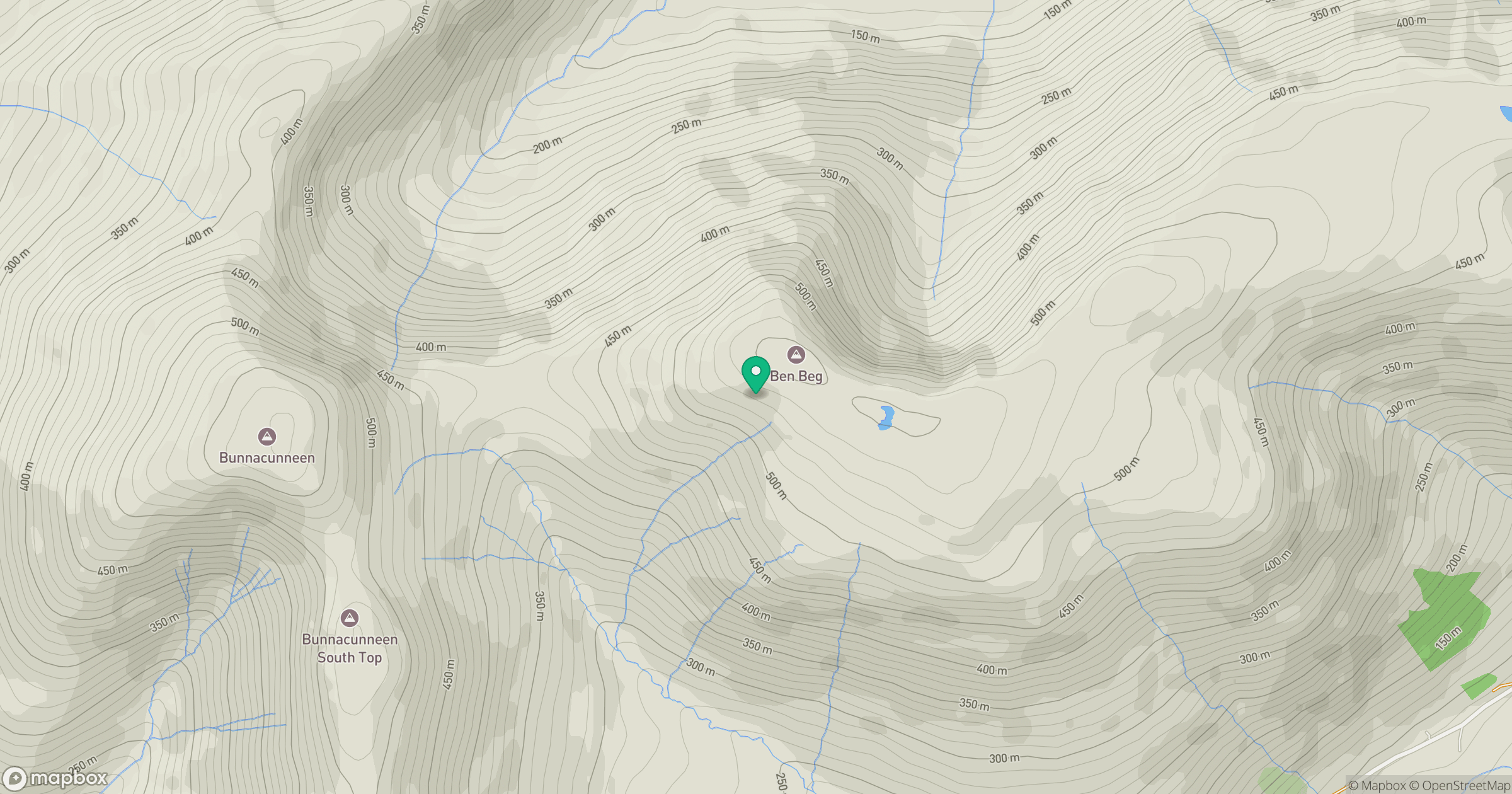
Grid reference: L950578
View on OpenStreetMapOpens a map in a new tab, centred on the hill.
Hills within 30 km
Straight-line distance, not a walking route or confirmation of access.
Croagh Patrick
764m
Mweelrea
814m
Roighne Mhor
427m
Maumtrasna
682m
Cnoc an Mhama [Knocknagussy]
454m
No comments yet. Be the first.